The use of drones and hyperspectral products to derive relevant area-wide information in agriculture and forestry have continued to grow in importance. Technological developments have meant that processes can be optimized and automated to achieve greater efficiency and productivity. An important aspect in this context is the use of drone flights and aerial photography.
The use of drones in combination with hyperspectral camera systems makes it possible to acquire spectral high-resolution information on agricultural land, forests and ecosystems, only to name a few. The products derived from the hyperspectral flight data enable analysis of the current condition of the land or observation of changes over time.
The ULTRIS X20 Plus is the dual-sensor version of our X20, designed for aerial mapping from a UAV. A second camera takes panchromatic images in parallel to the spectral camera. It provides a resolution of 1886 x 1886 pixels, providing incredibly detailed images. The extra data allows us to use pansharpening to enhance the images even further and increase the spatial resolution of the spectral data.
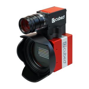
ULTRIS X20 Plus dual sensor camera for hyperspectral aerial mapping.
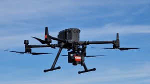
DJI M300 RTK with UXG Gimbal and ULTRIS X20P hyperspectral camera
Cubert offers a simple plug-and-play hyperspectral camera system in combination with gimbal for installation and use on the state-of-the-art UAV model DJI M300 RTK. The gimbal is specifically designed for the ULTRIS X20P hyperspectral camera. It allows stabilization of the hyperspectral camera during recording regardless of the drone’s movement or tilt. The gimbal ensures smooth connection via DJI Skyport, which allows for straightforward installation and handling. By including a mini PC, it is possible to acquire image and GPS data captured by the M300. The gimbal is featured with the CUVIS software, which can be accessed through the DJI controller to facilitate camera control and setting adjustments. By activating the camera via the drone, precise data acquisition is ensured, allowing informed decision-making.
Introducing the UXG Gimbal
The new UXG Gimbal is the link between the ULTRIS X20P and the DJI M300 RTK. The gimbal is connected via DJI Skyport, and has an integrated mini computer that runs the camera. Via DJI Skyport, the GPS data is gathered from the drone and written to each single image file (data cube).
Feasibility study Germany – Flight data acquisition and hyperspectral map products with X20P
A feasibility study was conducted to investigate the use of the hyperspectral camera system X20P in conjunction with the UXG gimbal on a DJI M300 RTK. The aerial survey took place near the Cubert site in Ulm, Germany, over an early season agricultural area. Weather conditions were stable (cloud-free and slightly windy) and thus ideal for the aerial flight tests.
The combination of the hyperspectral camera, gimbal and DJI 300 drone is characterized by its simple plug-and-play system. It allows a quick and uncomplicated setup, commissioning and handling of the complete system. The software-based planning of the flight route is carried out using DJI software (DJI Pilot 2) and enables automated acquisition of measurement data during the flight. During the flight, the hyperspectral measurement data is acquired with GPS coordinates and a defined overlap of flight strips and in the direction of flight.
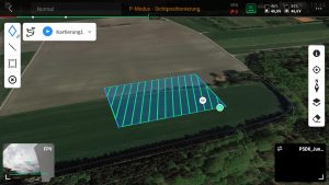
DJI Pilot 2 planning software with an example route
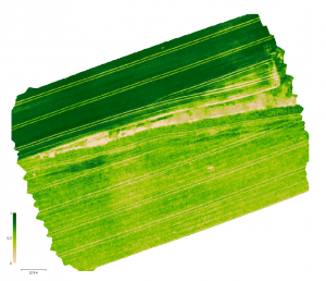
Hyperspectral flight data acquired in this way can be stitched to an orthomosaic. The individual images are computed using geoinformation system software (e.g., AgiSoft Metashape). Using the coordinates and the common pixels found between the images, distortions are eliminated and a final mosaicked image file (orthomosaic) is created. The hyperspectral image data are supplemented with elevation and position information and combined to a hyperspectral orthophoto, which due to the information content allows the generation of a wide variety of positionally accurate products.
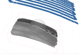
Point cloud from the common intersection points of the individual images with the corresponding individual images.
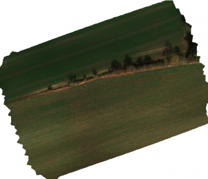
RGB True Color
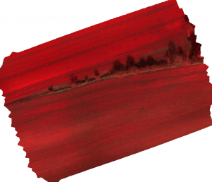
Colored Infrared (CIR)
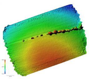
Digital elavation model (DEM)
Hyperspectral NDVI
